Plenty of hiking around Cleveland stays under the trees the whole way, and that is a good walk in its own right. These hikes with a view near Cleveland are the ones that climb to something at the top: a skyline deck, a sandstone ledge, a river bluff or a tower above the forest.
For the waterfalls and the longer valley walks, the full hiking and waterfalls guide near Cleveland has everything on a map. The trails below are sorted by what you see when you get there, with the closest views to downtown first.
Views toward Lake Erie and the downtown skyline depend on a clear day, so check the weather before you drive out for one.
Views from the top
Trails near Cleveland that end at a view
Parma
West Creek Reservation Skyline Trail
Best for: The closest skyline view
The Skyline Trail in the West Creek Reservation in Parma is a loop that climbs to an observation deck looking out at the downtown Cleveland skyline. It is one of the closest places to hike near the city on the south side, with the park entrance on West Ridgewood Drive.
Because it is so close, it works for a short outing after work or for showing a visitor the skyline from somewhere other than downtown.
Cleveland lakefront
Lakefront Nature Preserve
Best for: Lake Erie and the skyline without a climb
The Lakefront Nature Preserve sits on the Lake Erie shoreline off Lakeshore Boulevard on Cleveland’s east side. Inner and outer loop trails run along the water with views back toward the downtown skyline, and the birding is good.
The trails are easy, so the view comes without any real climb. Leave the dog at home, since dogs are not allowed.
North Olmsted
Rocky River Nature Center
Best for: A short, steep climb on the west side
At the Rocky River Nature Center in North Olmsted, a 155-step staircase climbs to the Fort Hill Loop, about 90 feet above the river, with wide views over the valley. It is a quick outing with a big view for anyone living in Lakewood, Rocky River or the western suburbs.
If the stairs are too much, the Wildlife Management Trail is a gentler way up.
Brecksville
Brecksville Reservation (Deer Lick Cave and Chippewa Creek Gorge)
Best for: A gorge overlook with a short walk in
In the Brecksville Reservation, a short walk off Chippewa Creek Drive reaches an overlook above the glacial Chippewa Creek gorge. It is one of the easier views on this list to reach.
With more time, the Deer Lick Cave loop follows part of the Buckeye Trail to a sandstone overhang, which gives you rock and deep woods to go with the gorge view. The reservation is a Cleveland Metroparks park in Brecksville, right next to the national park, so it is also a good first stop before heading into the valley.
Sagamore Hills
Brandywine Falls and Brandywine Gorge Trail
Best for: A waterfall seen from above and below
Brandywine Falls, near Northfield in Cuyahoga Valley National Park, is a 65-foot waterfall seen from upper and lower boardwalks, and the 1.5-mile gorge loop adds a longer walk. Expect stairs between the boardwalks.
Lots fill by midday on warm weekends. Arrive early, or park at the Stanford Trailhead and hike in, which also makes the view feel earned.
Kirtland
Chapin Forest Reservation
Best for: A ledge overlook toward the lake and the city
Chapin Forest Reservation in Kirtland is a Lake Metroparks park where a hilly loop climbs to a sandstone ledge overlook. On clear days you can see Lake Erie and the Cleveland skyline from the top, even from out in Lake County.
Expect real hills on the way up, and pick a clear day so the view is there when you arrive. The Lucky Stone Loop Trail is the one to look for.
Kirtland
Holden Arboretum
Best for: Treetop and tower views
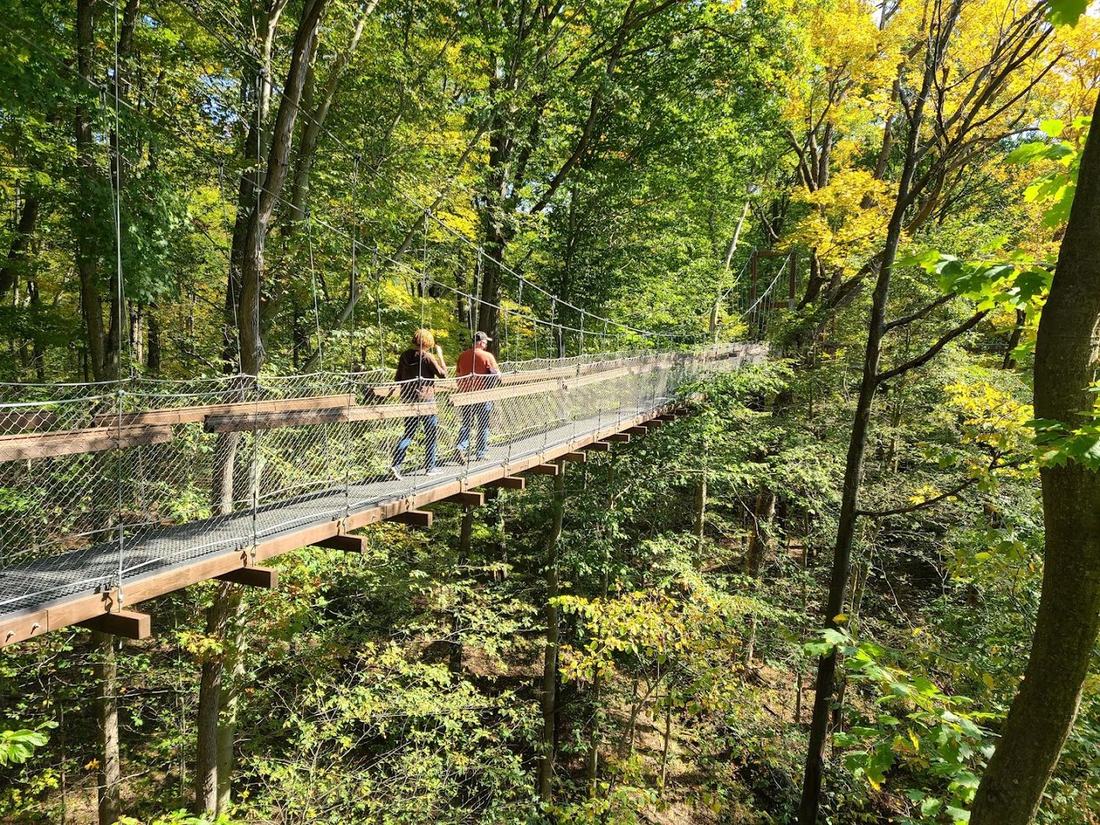
The Holden Arboretum in Kirtland has a 500-foot canopy walkway 65 feet off the ground and a 120-foot tower with views toward Lake Erie, plus trails across the grounds. It is the one place here where the view comes from a structure you climb.
Admission is paid. Chapin Forest is also in Kirtland, so the two make a full day of views in Lake County.
By side of town
Which view to pick based on where you live
From the west side and the western suburbs, the Rocky River Nature Center in North Olmsted is the nearest climb, and West Creek in Parma is a short drive for anyone on the south side. The Rocky River Reservation also has a longer route if you want to earn the Fort Hill view: park at South Mastick and follow the bridle trail to the Nature Center, about 6.5 miles round trip, watching for deer and birds along the river.
East siders have the Lakefront Nature Preserve inside the city and a pair of Kirtland options in Chapin Forest and the Holden Arboretum. Brecksville and Brandywine sit south of the city in and around the Cuyahoga Valley, closest for people in Independence, Broadview Heights and the southern suburbs.
If you only have time for one, choose by the view you want. For the skyline, go to West Creek or the Lakefront Nature Preserve. For Lake Erie from up high, go to Chapin Forest or the Holden tower. For river valleys and gorges, the Fort Hill Loop and the Chippewa Creek overlook are the ones.
Add a waterfall
Pairing a view with a waterfall
Blue Hen Falls is a 15-foot falls on the Buckeye Trail near the Boston Mill Visitor Center, fed by a spring upstream so it runs year round. Keep following the creek about three quarters of a mile to reach the Cuyahoga Valley’s Buttermilk Falls. It fits naturally into a Brandywine or Brecksville outing.
On the east side, the North Chagrin Reservation around Squire’s Castle has its own Buttermilk Falls, with an overlook, and it runs strongest after rain. The Chagrin Falls village waterfall is right in the middle of downtown Chagrin Falls, an easy stop with no hiking at all.
Good to know
Questions before you go.
Which view near Cleveland is best at sunset?
The Ledges Overlook in the Virginia Kendall area of Cuyahoga Valley National Park faces west and draws a sunset crowd. Weekend lots fill by midday, so arrive with time to spare.
Is there a longer, free hike on the east side?
Penitentiary Glen in Kirtland has about 8.5 miles of free trails through forest and fields beside a deep gorge. The gorge itself is open only on guided hikes.
Everything on one map
Find more trails and waterfalls near Cleveland
The <a href="/guides/best-hiking-waterfalls-cleveland/">full hiking and waterfalls guide</a> adds the waterfall hikes, valley walks and quieter trails around Northeast Ohio, with a map to plan from.